How to Decorate an Old NYC Apartment

Decorating an old New York City apartment can often be a very daunting process. If keeping up with he historical integrity of the building and or the apartment is a priority then it can be even more of a challenge. Luckily in this blog post we will assist you in various ways you can contribute to the vintage feel of your aged and nostalgic NYC apartment. We will list a range of decorative items and concepts that will ultimately create this vintage atmosphere that you seek. If you’d like to take a closer look at the decorative items below, feel free to click on the images as it will bring you to our online store where these items are currently being sold. If you have any questions please feel free to ask below!

1) Framed New York City Map Prints

How amazing do these vintage maps of New York City really look! Talk about beauty, history, nostalgia! A framed vintage map poster of NYC should be considered as on of pillars of creating historical decor in a Manhattan apartment. Guests and family members will be mesmerized by the historical beauty of these vintage relics.

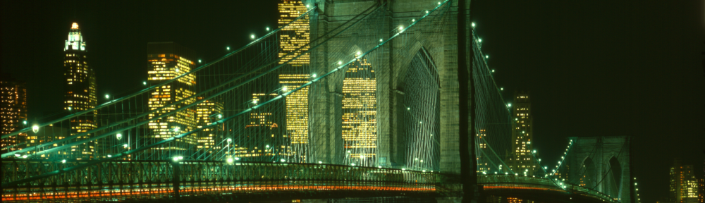
2) Brooklyn Bridge Throw Pillows

A throw pillow, especially one sporting a black and white photograph of the Brooklyn Bridge at night will not only create an iconic decorative feel to a desired room, but will also contribute to the historical feel of a domicile. The Brooklyn Bridge is recognized as one of the most prominent historical cornerstones of NYC history. It’s structure is over a century old and still has several of the engineered facets still intact. The throw pillow itself can be used to decorate a bed, a couch, even a window nook.

3) Manhattan Map Shower Curtains

Ya we went back with the vintage maps, this time though on shower curtains. Firstly I would just like to say that it is my belief that shower curtain designs are the singular item that stands out the most in ANY bathroom. Largely because it covers a huge surface area and allows the owner to express him or herself very easily in terms of the relative decor. The map designed and featured on the shower curtain above is that over lower Manhattan and features the many wards of NYC. I love this design as it also features a white background and would be great for a bathroom that gets tons of light and or has white backgrounds as well.

4) World Map Desk Lamps

We went with yet another vintage map, but this time we changed it up with a vintage map of the world. Old world maps just give off the decorative vibe of nostalgia and history. They look good and when lit up they look even better. These lamps are great for end tables in a living rooms, offices, studies, bedrooms and much more.

5) New York City Skyline Photograph Wrapped Canvas
We’ve done full circle I believe with wall art, as we’ve made our way to wrapped canvases. A wrapped canvas is great as it protrudes from the wall and displays material that is eye popping really. On the design above we have a vintage photograph of the NYC skyline presented before us. Skyline photographs of any city are amazing, but there is something about the NYC skyline that is just simply iconic. A wrapped canvas like this one would be perfect for a bedroom, living room, study or anywhere in which you need more wall art.

New York City Transit Line History (1918) – YouTube Video

Just wanted to share our latest YouTube upload which explores and examines a vintage map of New York City, more specifically a transit line map that was produced in 1918. In the video we zoom in and look at various historical aspects of this vintage map. If you have any questions or comments please leave them below!

Vintage Map of New York City (1909) – Examining and Exploring

new york city 1909 mapVintage Birds-eye Map of New York City (1909)

Today we’re going to take a look at one of our New York City Maps that’s in our historical collections that was produced in 1909. The map is displayed in a birds-eye 3d perspective in that we get to see building architecture, changes in landscape, bridges, parks and much more that is presented as if we were flying in a hot air balloon.

new york city 1909 map landmarksThere are several characteristics that I love about this vintage map of New York City. First of all it displays the various important landmarks throughout the metropolitan area. For example the Statue of Liberty is drawn with the labeling “Bedloe’s Island”. What’s interesting about this aspect of the map is that “Bedloe’s Island” on todays maps of New York City doesn’t exist. Instead the Statue of Liberty currently lies on Liberty Island. This is because “Bedloe’s Island” was renamed to “Liberty Island” as an act of congress in 1956. This gives us historical context that largely authenticates the observed publication date of 1909. Directly to the west of the Statue of Liberty lies Ellis Island. It is faintly drawn on the cartograph, for which about half of the island is actually visible. To the southeast of the Statue of Liberty lies Governors Island in which Fort Columbus and William Castle is labeled. If we look to the north east of Governors Island we see two of the great suspension bridges of New York City. Drawn and labeled are the Brooklyn and Manhattan bridges crossing over the East River. I really love the amount of detail that exists with these various historical landmarks of NYC. This is just one of the many special aspects of this vintage cartograph.

new york city 1909 map hudson river transit lines

Another characteristic of this map that I believe cannot be overlooked is that the transit lines and tunnels of New York City are labeled throughout. For example if you look long the Hudson river side of lower Manhattan you see that the Pennsylvania Railroad route is labeled, the Erie Railroad, the Hudson Manhattan Tunnel and various ferry lines that travel back and forth across the Hudson River.

new york city 1909 map east river transit linesOn the East River though there are only a few transit lines labeled as you can see the Interborough tunnel labeled, as well as the Belmont Tunnel, and Pennsylvania Railroad tunnels. Tunnels and ferry lines as we can see on the map are more predominate on the Hudson River vs. The East River. What interesting about this aspect is that the Hudson River is much wider then the East River. The Cost and resources needed for building a bridge across the East River must have been significantly less then a proposed plan for building a bridge over the Hudson. A very interesting thought and explanation to the reasons that bridges only existed on the western side of Manhattan.

new york city 1909 map transit line comparisonI really love birds-eye perspective maps because they give the viewer and idea of the historical growth of a city. It also presents the vertical growth of skyscrapers as well as the formation of various neighborhoods and boroughs. Generally on this map though, we vague drawn buildings throughout. We see mediocre boxes with dots that symbolize windows. Building architecture though is detailed more specifically as we get into highly condensed areas of New York City.  For example in lower Manhattan, right next to Battery Park, we see a few skyscrapers detailed with individual characteristics in terms of shape. If we look to the western side of the Hudson River, we see piers and docks drawn with specific details as well. Also various parts of Brooklyn have architecturally detailed buildings throughout. Ultimately what this tells me is that the map was meant not for close inspection of the general areas, but more pulled back approach that gives a worldly view perspective. The map wants you to see the magnificence and growth of the City of New York. That is why I believe birds-eye perspective maps are so special and unlike the overhead 2-D street view maps.

Check out our musical preview of this vintage map from 1909:

Also we have this vintage map of New York City available on a fully customizable poster print from our online shop. Click the image and link below to take a closer look!

Vintage New York City Map – Postcards

Check out some of our vintage New York City Map postcards available for purchase on our online store. The vintage New York City map postcards below are perfect for hanging on the fridge, decorating a room, sending invitations, creating advertising mailers and much more. The postcards come in landscape (5.6″ x 4.25″ ) and portrait (4.25″ x 5.6″) layouts. The postcards are printed on ultra-heavyweight card stock with a glossy finish. There is also no minimum on the order size, for example you can order 1 postcard or order 5,000 postcards. Also the larger the bulk purchase, the larger the discounts. The maps range in publication date from the 1600’s to the early 1900’s. The maps also range in terms of perspective, for example some maps have a birds-eye perspective displaying 3D characteristics  that show changes in elevation, building architecture, vegetation, railroads and railroad cars etc. Other maps are standard overhead 2D street view maps. Take a few minutes and check out the vintage New York City map postcards below. If a postcard peaks your interest feel free to click the image or link to take a closer look. If you have any questions or comments or are wondering if there are additional discount codes, please leave a comment below.

Vintage Map of New York City (1878) Post Card
Vintage Map of New York City (1878) Post Card by Alleycatshirts
View New york city Postcards online at zazzle
Vintage Map of New York City (1846) Postcard
Vintage Map of New York City (1846) Postcard by Alleycatshirts
Look at New york city Postcards online at Zazzle.com
Vintage Map of New York City (1890) Post Card
Vintage Map of New York City (1890) Post Card by Alleycatshirts
Shop for New york city Postcards online at Zazzle.com
Vintage Map of New York City (1886) Postcard
Vintage Map of New York City (1886) Postcard by Alleycatshirts
Look at New york city Postcards online at Zazzle.com
Vintage Map of New York City (1831) Post Cards
Vintage Map of New York City (1831) Post Cards by Alleycatshirts
Check out other New york city Postcards at zazzle.com
Vintage Map of New York City Harbor (1864) Postcard
Vintage Map of New York City Harbor (1864) Postcard by Alleycatshirts
Check out New york city Postcards online at zazzle

New York City Metropolitan Map (1912) – Musical Preview YouTube Video

Just wanted to share with you our latest YouTube upload displaying a vintage map of the New York City Metropolitan area that was produced in 1912. In the video we zoom in, pan, and fade various illustrative points of interest in the New York City area that are contained in this historical cartograph. The video also features classical folk music that creates a cinematic feel in regards to the examination of this vintage map. The video is about 2 1/2 minutes long and is well worth a watch. Tell us what you think by leaving a comment below!

Vintage New York City Map (1909) – Musical Preview

Hey guys just wanted to share a newly uploaded video to our YouTube channel displaying a vintage map of New York City produced in 1909. The video zooms and examines the various geographical aspects of this historical map while playing classical music in the background. Definitely check out the video and tell us what you think by leaving a comment below!

New York City Map – Duvet Covers

Time to snuggle up with some of our customly designed New York City Map microfiber duvet covers. The maps ddesigned on these covers range in terms of their publication date, some of the maps were published as early as the 1600’s and others extend to the early 1900’s. The maps also range in terms of the perspective in which they are conceived, some are birds-eye perspective maps while others are overhead 2d perspectives.

The covers come in multiple sizes including King, Queen and Full. The covers are hand sewn, machine washable and come with a hidden zipper for assembly and care. The duvet insert is not included.

Vintage Map of New York City (1869) Duvet Cover

Vintage Map of New York City (1911) Duvet Cover

Vintage Map of New York City (1890)

Vintage Map of New York City (1884) Duvet Cover

Vintage Map of New York City (1901) Duvet Cover

Vintage Map of New York City (1831) Duvet Cover

Vintage Map of New York City (1886) Duvet Cover

Vintage Map of New York City (1846) Duvet Cover

Vintage Map of New York City (1807) Duvet Cover

Vintage Map of The New York City Harbor (1864) Duvet Cover

Vintage Pictorial Map of New York City (1879) Duvet Cover

Vintage Pictorial Map of New York City (1879) Duvet Cover

Vintage Map of Lower New York City (1860) Duvet Cover

Vintage Pictorial Map of New York City (1873) Duvet Cover

Vintage Pictorial Map of New York City (1874) Duvet Cover

Vintage Pictorial Map of New York City (1672)

Vintage Map of New York City (1840) Duvet Cover

New York City History and Map (1897) – YouTube Video Musical Preview

This map comes from our updated NYC map collection, it is a vintage map of New York City produced in 1897. We’ve recently produced a YouTube video that examines and explores this vintage map while playing classical piano music in the background. Please check out the preview by playing the video below!

Manhattan History and Map (1847)

Just wanted to share with you guys our newest Youtube video upload. In the video we explore and examine a vintage map of Manhattan that was produced in 1847. The map is an overhead 2d view of lower New York City. The map is very detailed in that streets, harbors, rivers and borough are labeled. Check out the video and leave a comment below telling us what you guys think!

Historical Central Park Map Collection

Here is our collection of our vintage Central Park NYC maps that we have in our possession. The publication dates of these maps range immensely and these maps also come in numerous perspectives.  Take a look around and if you have any questions please leave them below! Enjoy!

Vintage Central Park Map (1879)


Vintage Central Park Map (1879)


Vintage Central Park Map (1860)


Vintage Central Park Map (1870)


Vintage Central Park Map (1875)


Vintage Central Park Map at 59th and 5th ave Entrance (1869)

Vintage Central Park Map (1914)