How to Decorate an Old NYC Apartment

Decorating an old New York City apartment can often be a very daunting process. If keeping up with he historical integrity of the building and or the apartment is a priority then it can be even more of a challenge. Luckily in this blog post we will assist you in various ways you can contribute to the vintage feel of your aged and nostalgic NYC apartment. We will list a range of decorative items and concepts that will ultimately create this vintage atmosphere that you seek. If you’d like to take a closer look at the decorative items below, feel free to click on the images as it will bring you to our online store where these items are currently being sold. If you have any questions please feel free to ask below!

1) Framed New York City Map Prints

How amazing do these vintage maps of New York City really look! Talk about beauty, history, nostalgia! A framed vintage map poster of NYC should be considered as on of pillars of creating historical decor in a Manhattan apartment. Guests and family members will be mesmerized by the historical beauty of these vintage relics.

2) Brooklyn Bridge Throw Pillows

A throw pillow, especially one sporting a black and white photograph of the Brooklyn Bridge at night will not only create an iconic decorative feel to a desired room, but will also contribute to the historical feel of a domicile. The Brooklyn Bridge is recognized as one of the most prominent historical cornerstones of NYC history. It’s structure is over a century old and still has several of the engineered facets still intact. The throw pillow itself can be used to decorate a bed, a couch, even a window nook.

3) Manhattan Map Shower Curtains

Ya we went back with the vintage maps, this time though on shower curtains. Firstly I would just like to say that it is my belief that shower curtain designs are the singular item that stands out the most in ANY bathroom. Largely because it covers a huge surface area and allows the owner to express him or herself very easily in terms of the relative decor. The map designed and featured on the shower curtain above is that over lower Manhattan and features the many wards of NYC. I love this design as it also features a white background and would be great for a bathroom that gets tons of light and or has white backgrounds as well.

4) World Map Desk Lamps

We went with yet another vintage map, but this time we changed it up with a vintage map of the world. Old world maps just give off the decorative vibe of nostalgia and history. They look good and when lit up they look even better. These lamps are great for end tables in a living rooms, offices, studies, bedrooms and much more.

5) New York City Skyline Photograph Wrapped Canvas
We’ve done full circle I believe with wall art, as we’ve made our way to wrapped canvases. A wrapped canvas is great as it protrudes from the wall and displays material that is eye popping really. On the design above we have a vintage photograph of the NYC skyline presented before us. Skyline photographs of any city are amazing, but there is something about the NYC skyline that is just simply iconic. A wrapped canvas like this one would be perfect for a bedroom, living room, study or anywhere in which you need more wall art.

Historical Castle Garden Photographs

In this post we will be examining various historical photographs of Castle Garden in NYC. After each photograph we will give a title to the image as well as a publication date. Below that information we will also provide a brief synopsis of what is contained and displayed in the photograph itself. If you have any questions or comments about the material please feel free to leave them below.

Castle Garden Immigrant Depot Entrance (1870 – 1890?)

Interesting photograph of Castle Garden as it displays one of the entrances into the main immigrant depot. We know that this is the depot largely because “Castle Garden” is written in huge text on the front of the building. What I really like about this historical photograph is the various people displayed infront of the building itself. From the looks of it the people range from immigration officers to actual immigrants. It also appears that this photograph was taken either during the late fall or winter as the trees infront of the building have no leaves. The publication considered to have been taken in the later part of the 1800’s, but we cannot confirm that. The only thing we can confirm is that Castle Garden was in operation from 1855 – 1890.

Castle Garden Main Building (1855 – 1870?)

If we look at this photograph we obviously can see the Castle Garden immigration building (the same one in the previous photograph). What’s interseting about this photograph is that there is practically nothing around the main building, leading me to believe that this photograph was taken in the earlier years of operation. This photograph was used in a publication titled the “The Kings Handbook of New York City” – 1893. We know that Castle Garden stopped operation in 1890, so this is obviously a photograph from a previous date.

Castle Garden and New York City Harbor (1902)

A wonderful panoramic photograph we have in our collection that displays Castle Garden off in the distance as well as the surrounding buildings and areas. If you look really really far into the New York City Harbor you can see the statue of liberty. I really like that you get to see a side street next to castle garden in which you get to see the nearby businesses and horse and buggies. Based on the park in the foreground of Castle Garden I can only assume that this photograph was taken in a late spring, summer or early fall time period in 1902.

Castle Garden and NYC Harbor Aerial Photograph (1902)

We have another aerial photograph of Castle Garden and the NYC harbor, again like the last one it was taken in 1902. In the far distance of the harbor you can see the Statue of Liberty a little better. You can also see the various ships throughout the harbor. Based on the steam coming from the boats and buildings and the leafless trees around Castle Garden I’m going to make the assumption that this photograph was taken during the winter months.

If you would like us to find more historical photographs of Castle Garden or other parts of New York City please leave a comment below and make a request!

Discovering New Amsterdam – 1600’s Cartography

One of the earliest maps of New Amsterdam is displayed right below this paragraph. The map displays a very basic illustration of lower Manhattan and was originally produced in 1664. The map was produced for James the Duke of York in order to lay down the first plans for the construction of a new Colony. Below the map we will examine and explore various cartographic attributes that make this map absolutely stunning. If you have any questions or comments please feel free to leave them below!

Quite an interesting early map of New Amsterdam we have displayed above! There is no doubt in my mind that this map was originally produced in 1664 as you can see a developmental and early illustration of lower Manhattan. The other aspects that overwhelmingly confirm the publication date is the spelling as well as the labellings throughout this map. Longe Isleland is obviously spelled quite different then it is today and to the left of the map you can clearly see the labeling “The Dukes Plan” “A Description of the Towne of Mannados-(Manhattan) or New Amsterdam”. Also if we look at the river on the opposite side of long island we see “Hudfrons River”, an old spelling of the Hudson River no doubt.

This map presents many clues to us about what New York City was like back in 1664. For example look at the plentiful amount of ships over in the East River. What this tells me is that many ships back in the mid 1600’s were landing and porting their ships along this area and were provided with easier access to the Atlantic ocean from side of New Amsterdam. Its even true today that more ships are in port along the East River, look at where the U.S. Naval Shipyard is… located on the East River for easy access to the Atlantic.

We can obviously see that lower Manhattan in this map is somewhat underdeveloped. From the looks of it, it seems there were only 3 avenues and mini neighborhoods scattered throughout Manhattan’s lower quarter. Beyond these locations we see sporadic illustrations possibly detailing the planning of new neighborhoods and or developing and clearing the land on the island. The lower quarter of New Amsterdam is drawn with a vertical line with 5 pointed dividers. This line on the map represents the fortifications built on the upper section of this colony. I have evidence to support this finding that this is a fortification by cross-referencing it with another map of New Amsterdam below:

Fortifactions new amsterdam numbered

Notice the 5 points in the image above, well there are also 5 points in the same location on the map above this one. So without a doubt I can tell you that they fortified this section of New Amsterdam.

Another aspect that stands out to me that are on both of these maps is the fortification located at the southern tip of lower Manhattan. This fort has been called so many different names throughout time. It has been called Fort Amsterdam, Fort George, Fort William Henry and much more. But as you can see on both maps It gave the dutch a strategic advantage to defending lower Manhattan. Not only did it provide an advantage with line of site scouting for invaders coming from the Atlantic or the Hudson, but it also contributed and gave the Dutch a strategic vantage point for their cannons to fire upon incoming ships as well a fall back location for the island as a whole. The 1st map displayed does not display the cannons in the 4 quadrants of the fort. The 2nd map displayed though overwhelmingly does.

fort amsterdam cannonsThese are just a few of the various historical aspects that we’ve explored and uncovered on these old vintage maps of New Amsterdam. Please feel free to subscribe to our blog on the right hand side! We will be continuing this exploration of History of New York City and we blog constantly. If you have any questions or comments about this post please feel free to comment below!

History of Harlem and The River Ferries

When the original Dutch settlers began to flock to the hills and valleys of Harlem, the first thing they did was to look around for a suitable name. Immediately a great dissension arose, each stout burgher insisting that the spot should be called after his own native town in old Holland. Finally they decided upon a most happy expedient; they resolved to style the place “Harlaem,” for the simple reason that none of them had come from that village, and as a result, no one could object. Such, we learn, is the origin of the name which for a long time appeared on the steam railroad cars. “New York and Harlaem Railroad.”

In the year 1666, when the sleepy residents of Harlaem were comfortably settled and enjoying life around their immense fireplaces, with long-stemmed pipes in their mouths, and all accustomed to going to bed at four o’clock every afternoon. Someone made the startling announcement that beyond the broad river that flowed past their doors was to be found the most beautiful farming land imaginable, just the site for their favorite “boueries”. This was enough, for once they hastily rose to the occasion. They must have a ferry at once to carry them across to those fair shores where their “boueries” were to be.

The site selected was about 126th street and the East River, where the old “Harlaem Road” terminated. The peculiarly slanting and irregular boundary lines, which even to-day are found in this section of Harlem and which are so at variance with all existing streets and avenues, and form such a bete-noir alike to title-searchers and surveyors, is lasting evidence of the former existence of this early highway.

A ferry meant a ferryman, and in 1667 Johannes Verveelen was duly installed, along with an African American man by the name of “Matthys”. He was allowed to furnish food, drink and lodgings to the weary wayfarers he ferried across, but not a drop to the indians.

Here are some of the curious rates that he charged for carrying travelers from Harlaem to the Bronx shore:

“For every passenger, 2 pence silver or six pence wampum; for every ox or cow that shall be brought into his ferry-boat, 8 pence or 24 stivers; and cattle that swim along over pay but 1/2 price.

“He is to take for diet, every man for his meal, 8 pence or 24 stivers wampum; every man for his lodging, 2 pence a man or 6 stivers wampum; every man for his horse shall pay 4 pence for his night’s hay or grass, or 12 stivers wampum.”

“Signed, THO: DE LAVALL, Mayor.” “Dated July 3rd 1667”

New York City Map – Mousepads

Introducing …… New York City map mousepads that are currently available on our online store. Perfect for the professional office or the casual user, these mousepads are dust and stain resistant and are sized 9.25″ x 7.75″. The mousepads also include a no slip bottom and are printed with full color quality.  The New York City maps designed on these mousepads range in style and publication date. Some of the maps are displayed with a birdseye perspective while others are an overhead 2d perspective. The maps featured on these mousepads range from being originally produced as early as the 1600’s all the way to the early 1900’s. Take a few minutes and browse the collection below, if you want to take a closer look at a specific mousepad feel free to click on the images and or links. If you have any questions please don’t hesitate to leave a comment below.

Vintage Map of New York City (1884) Mouse Pad
Vintage Map of New York City (1884) Mouse Pad by Alleycatshirts
View New york city Mousepads online at zazzle
Vintage Map of New York City (1886) Mouse Pad
Vintage Map of New York City (1886) Mouse Pad by Alleycatshirts
Look at New york city Mousepads online at Zazzle.com
Vintage Map of New York City (1831) Mouse Pad
Vintage Map of New York City (1831) Mouse Pad by Alleycatshirts
Look at more New york city Mousepads at zazzle

144533862207445453?rf=238063820583157051″>Vintage Pictorial Map of New York City (1672) Mouse Pad by Alleycatshirts
Browse New york city Mousepads

Historical Brooklyn Photography – Examination

In today’s post we are going to travel through time and examine various historical photographs of Brooklyn New York. The photographs that we are going to display and explore are going to range in content and subject. Some photographs will contain architectural elements such as the Brooklyn Bridge, other photographs will display group photographs of lets say … the Brooklyn Dodgers. After each photograph we will give a brief synopsis of the content and examine various elements of the photograph that stand out in terms of historical significance. If you have any questions please don’t hesitate to comment below!

Streets of Brooklyn by the Brooklyn Bridge (1889)

This is a great photograph as you can clearly see the Brooklyn bridge off in the background. I also love the man in the foreground as it gives perspective to the size of the Brooklyn bridge. If you notice the tree to the left of the street, it is bear with no leaves upon it. This indicates to me that this photograph was taken either during a late fall or winter time period. I can also conclude this because the man walking towards the camera seems to be warmly dressed. Another interesting aspect within the photograph seems to be the street itself. It is completely composed of cobblestone, which is probably much different than it exists today.

 Brooklyn NY Blizzard of 1888 (1888)

I like this photograph alot! you get to see the aftermath of a major snowstorm that hit the Brooklyn New York area. Also what I find interesting is the clothing attire for people during the winter. It seems women back in 1888 wore there hair up in beanie like headwear. The snow accumulation from this snowstorm seems to be about 4-6 feet high.

Brooklyn Bridge Railway (1900 – 1910)

This is a great looking photograph as you get to see what the Brooklyn bridge railway was like back in the early 1900’s. In the foreground of the photograph you clearly see a moving trolly. Towards the back of the photograph and on the left hand side you see several billboard advertisements such as a suit tailor advertisement. Upon zooming into this photograph the price of a 2 piece suit back in the early 1900’s was advertised on this sign for $14.50. Even farther back from this billboard advertisement, I see another advertisement displaying an ad for Curley shaving razors. Towards the middle section of the bridge you can see several pedestrians walking the bridge either to catch a train or to walk over to Manhattan.

Brooklyn Dodgers Baseball Team (1895)

I had to include this photograph in this post largely because its an iconic photograph that largely displays Brooklyn history. In this photograph you obviously see the Brooklyn Dodgers baseball team. You get a glimpse at the baseball clothing that was prevalent in 1895. To me what stands out the most is the style of hats they wore. The white pinstripe hats are very iconic to the style of old school baseball.

Brooklyn Navy Yard (1945)

A beautiful birdseye view of not only the Brooklyn Naval yard, but also Lower Manhattan. In the middle of the photograph you can clearly see the naval yard and the ships that are in port. To the right of the yard you can see a major mechanical crane. Situated around the Naval yard is smokestacks and factories that most likely is fabricating parts to produce ships. In the far distance to the left you can see the Brooklyn Bridge, and to the right you can see the Williamsburg bridge.

Coney Island Brooklyn NY Surf Avenue (1912)

Had to include this one as it is an important part to Brooklyn New York. This photograph displays a section of Coney Island, more specifically Surf Avenue and Luna Park. In the photograph we see several people walking along the sidewalks, we see several hose and buggies. We see the entrance into the Luna Park as well as several different businesses along the road. For instance on the left side of the photograph we see an amusement park business, more specifically a shooting gallery. On the right side of the Luna Park entrance we see a hotel labeled “Kisters”.

Ellis Island Photographs – YouTube Video

Hey everyone! Just wanted to share our newest Youtube upload which explores and examines various old photographs relative to Ellis Island history. If you have any comments or questions please don’t hesitate to leave them below!

New York City Map – Messenger Bags

Introducing…. drumroll please…… New York City map messenger bags! That’s right, sport your love for the greatest city in the world on these customly design Rickshaw messenger bags. The bags are manufactured with a rugged polyester material, their dimensions are 11″ hieght x 18″ width x 6″ Depth. The bags are also water resistant and machine-washable. The inside of the bag has 1 large main compartment accompanied by 2 front pockets. It’s extremely lightweight and comfortably accompanies a persons body. The bag can easily hold a 13″ laptop and comes with a quick adjust should strap. The maps that are designed on these messenger bags range in publication dates. Some were originally produced as early as the 1600’s all the way to the 1900’s. The maps also range in perspective in that some are birds-eye perspective maps and others are overhead 2D maps. If you have any questions please don’t hesitate to leave them below. Also feel free to click on the images and link to take a closer look at these wonderful New York City Map messenger bags.

Vintage Map of New York City (1911) Courier Bag
Vintage Map of New York City (1911) Courier Bag by Alleycatshirts
Look at more New york city Messenger Bags at zazzle
Vintage Map of New York City (1886) Messenger Bag
Vintage Map of New York City (1886) Messenger Bag by Alleycatshirts
Check out New york city Messenger Bags online at zazzle

Ellis Island Historical Photography and Examination

In this post I just wanted to include some great photographs in our collection that Illustrate the nostalgia of Ellis Island and New York City history in general. We will not only list each photograph, but we will also describe and examine of the subject matter and how it relates to Ellis Island and New York City Immigrant history. Also all the images and links are clickable so if you wish to download the image feel free to do so. If you have any questions please don’t hesitate to leave them below!

Ellis Island Boat Launch Station – 1913

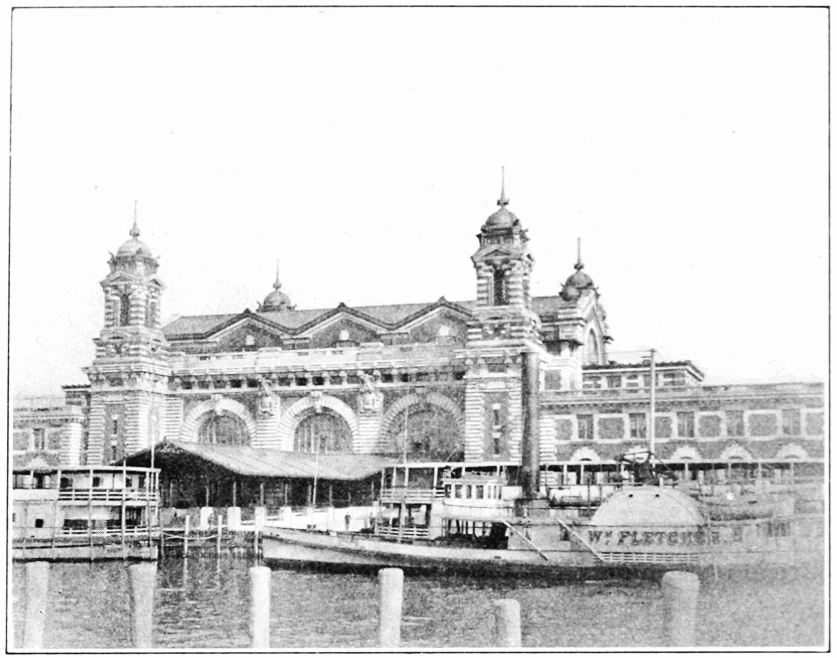
An interesting photograph showing a boat launch station at Ellis Island. If we look closely one of the riverboats is labeled with a name that reads “W.M. Flectcher”. Obviously in the background of the photograph we see the main terminal building for arriving immigrants to Ellis Island.

Immigrants Arriving to Ellis Island – 1912

In this photograph we see several immigrants arriving to Ellis Island with suitcases and various packages. From what it looks like there are 2 immigration officers in between the arriving immigrants that are directly focused on the camera. A 3rd officer is to the right of them but seems to be more focused on the arriving people. In the background of the photograph you can see the various buildings that comprise Ellis Island .

Boarding Cutter Ship at Ellis Island

This photograph seems to be sporting the arrival of several smaller ships to Ellis Island. What I think is cool about this photograph is the American Flag that hangs on the back of the ship in the foreground. Notice anything different about that flag? Well it seems that it’s missing about 37 stars on it and contains only 13. The number 13 I believe is in direct accordance with the original 13 colonies of America. Anyways besides that you get to see a few buildings and structures that are on Ellis Island as well.

Ellis Island Immigrant Station – 1893

Oh Boy! I love this photograph as it gives us a nice collage of several aspects of Ellis Island. The middle photograph details the main immigration station on Ellis Island. Now you might ask yourself, “Well it looks different than the structure now?” That’s because it is different, the one presented in this photograph was destroyed by a raging fire in 1897. Unfortunately during the fire many of the records were lost for good. Other parts of the photograph show a detention center, a dock landing area, a dining hall and the house of a Surgeon.

Walking to the New York City Departure Boats – 1913

This photograph I think is very iconic in terms of the achievement of the American dream. The photograph above displays several immigrants walking towards the boats that will deliver them from Ellis Island directly to New York City. In the photograph we see the immigrants holding numerous packages and suitcases as they ascend to the boats. We can right off the bat tell that we’re near the docks because to the left of the photograph we can see a life preserver hanging on a wooden beam that reads “Ellis Island”. If we look towards the background and more specifically to the right we can see an Ellis Island immigration officer watching the crowd as it arrives to the boats.

Construction and History of The Brooklyn Bridge

The details of constructing the Brooklyn Bridge towers have been performed under the eyes of all Brooklyn people. Since the tower of Babel and the great pyramid of Egypt, there has been no more massive structures. Block upon block the granite tiers were laid, until a total hieght of 278 feet above high water was attained. The New York tower is thus 356 feet high from the foundation. Further inland the equally ponderous anchorages were progressing, and although not so familiar because largely concealed by the surrounding buildings, are not the least important or least expensive details of the bridge. Still lower structures of solid masonry support the approaches.

In October 1878, a sensation was created by a communication to the N.Y. Sun, purporting to reveal a plot for blowing up the bridge. It was alleged that a certain stone-mason, inspired by the ambition of the “youth who fired the Ephesian Dome,” had secreted charges of dynamite between the courses of stone at the base of the tower on which he was engaged. The explosive was connected by wire with the exterior at points known only to the wicked mason, and at a suitable time, probably while the cities were celebrating the completion of the bridge, it was his intention to wreck the structure. A mysterious diagram was also published, said to be a copy of the working plan of the unprincipled wretch, showing the places of deposit and the line of connecting wires.

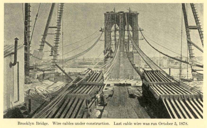
On May 29th 1877, a single wire was carried across the river attracting much attention as the first connecting link, with the “promise and potency” of greater things. The process of cable-making now commenced. Each cable is composed of 5,296 thicknesses of wire laid parallel. The wire is continuous in varying lengths, joined by a small screw coupling, which can never unscrew, the invention of Colonel Roebling and A.V. Abbot. At the anchorage the wire “returns” around a “shoe,” and so is carried from shore to shore until the cable is complete. It is then closely wrapped, forming a solid cylinder 15 3/4 inches in diameter. The total length of each cable is 3,578 feet, and it contains 3,589 miles of
wire.

Upon the four great cables thus composed, the suspended superstructure retains it’s inital and primary weight distribution. To avoid any lateral strain upon the towers, the cables are in no way fastended to them, but rest on movable “saddles” at the point of contact. These saddles, with their burdens, move to and fro upon 45 iron rollers of 3 1/2 inches diameter, which readily yield to the varying tention of the wires as the weight is shifted from the land to the river span, or vice versa.

A temporary structure called the “foot-bridge,” was thrown across the river during the cable-making, for the convenience of construction. It was much higher than the roadway of the permanent bridge, following the cables over the summits of the towers, instead of
passing through the arches. A trip across the foot-bridge on a clear, cool day, afforded an exciting and pleasurable novelty. The unaccustomed head would be dizzy, and both hands nervously clutch the wire hand-rails. Between the slats on which on walked were glimpses of gleaming water, and decks of toy ships and ferry boats with pigmy passengers. As our walk was but three feet wide, a ribbon through the air, it easily suggested a reminiscence of the narrow bridge Al Sirat, over which the people of Islam believe that the spirits of the departed must pass to paradise. The faithful tremble, but cross in safety, while unbelievers topple over into the fearful gulf. To avoid such thoughts, the traveler could look abroad and get distraction and delight from the wide panorama which the vicinity of New York affords.

How does the bridge look? is a question frequently asked. It’s external appearance from a distance is familiar from engravings which were exhibited everywhere before either one of the towers had reared its head above the tide. Some new ideas of details may perhaps be obtained from an imaginary trip to New York in July, 1883.

Descending from the horse car (or more happily the elevated railroad?) at the corner of Fulton and Sands streets, we notice no special change from the present aspect of Fulton street, but moving up Sands we find the southwestern corner of Washington street converted into the head of a busy thoroughfare, which closes abruptly at narrow Sands street; but the pressure there will soon be relieved, for a portion of the block bounded by Sands, Washington, High and Fulton has been taken as a public sqaure, that will be worthy the dignity of our bridge, and conduce to the convience of its traffic.